
Far East Independence Movements Map
2025/07/08·StepFun can make mistakes, check important info.
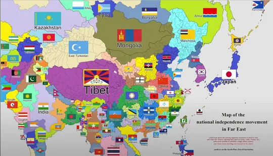
This image is a map illustrating the national independence movements in the Far East. It highlights regions and their respective flags, indicating areas with separatist or independence movements. Here are some key points from the map:
General Features:
-
Regions and Flags:
- The map is divided into various regions, each marked with a flag, representing either existing countries or hypothetical independent states.
- Notable regions include Tibet, East Turkestan (Xinjiang), Manchuria, Mongolia, Bashkiria, Kazakhstan, Kyrgyzstan, Tajikistan, Uzbekistan, and many others.
-
Focus on China and Surrounding Areas:
- Many regions within the historical boundaries of China are highlighted, such as Tibet, East Turkestan, Manchuria, and others, suggesting these areas have movements seeking greater autonomy or independence.
- Other countries like India, Russia, Japan, and Mongolia are also divided into sub-regions with their respective flags.
-
Separatist Movements:
- The map references regions with active or hypothetical separatist movements, such as:
- Tibet and East Turkestan within China.
- Various regions in India (e.g., Sindh, Rajasthan, Bengal, Parsis, etc.).
- Regions in Russia (e.g., Altay, Tuva, Buryatia, Amur, etc.).
- Parts of Japan (e.g., Ryukyu).
- The map references regions with active or hypothetical separatist movements, such as:
-
Note at the Bottom:
- The note clarifies that this is a hypothetical map showing existing separatist movements in the Far East.
- It mentions that some regions might establish单一的ethnic countries (ethnically homogeneous states).
- The map is not necessarily reflective of current political reality but rather an illustration of independence or separatist aspirations.
Specific Regions Highlighted:
-
China:
- Tibet, East Turkestan (Xinjiang), Manchuria, and other regions are shown with distinct flags, indicating separatist movements.
- Central and southern China are divided into various ethnic or regional identities (e.g., Hakka, Fujian, Canton).
-
India:
- The map divides India into multiple regions such as Sindh, Rajasthan, Gujarat, Bengal, Parsis, and others, each with its own flag.
-
Russia:
- Several regions in Siberia and the Russian Far East are highlighted, including Altay, Tuva, Buryatia, and Amur, suggesting potential independence movements.
-
Japan and Korea:
- Japan is divided into Ryukyu and the main islands.
- Korea is shown as a single entity in this map.
Historical and Political Context:
- This map reflects ethno-linguistic and cultural divisions rather than current political borders.
- It is important to note that the map is speculative and does not represent internationally recognized borders or governments.
Source:
- The map is credited to Jacob Pius and was created on 2018.07.01.
This type of map is often used for discussion on ethnic, cultural, or political autonomy movements but should be viewed with an understanding of its hypothetical nature.